-
{{#each toplargenavdata}}
{{#if expand}}
-
{{text}}
{{/if}}
- {{text}} {{/each}}
{{#each popup}}
{{/each}}
-
{{#each topsmallnavdata}}
{{#if expand}}
-
{{#if icon}}
{{/if}}
{{text}}
{{/if}}
- {{text}} {{/each}}
{{#each popup}}
{{/each}}
-
 Wilkes Barn Quilt Trail | Ben Long | Blue Ridge Parkway | US 421 Scenic Byway | Upper Yadkin Way | Yadkin Valley Scenic Byway
Wilkes Barn Quilt Trail
Reflect on times past as you travel through the beautiful pastoral landscapes of Wilkes County, with generational homesteads, barns and farms. Quilt patterns were chosen from centuries old, placed on barns of local residents wishing to ensure this legacy, and enjoyed by all who gaze and recognize it as a form of art. Sharing rich heritage through quilt design, Wilkes County Quilters Guild in partnership with Cultural Arts Council of Wilkes present a Barn Quilt Trail. Wilkes County Public School art students participated in producing three blocks, initiating future generations to keep the historic quilting tradition alive.
Presently there are 16 quilts displayed in Wilkes County, NC:
- 8 Point Stars - 11605 W. US 421, Purlear
- American Flag -Record Park, 6th & E St, N. Wilkesboro
- Baby Bovines - 1842 Country Club Rd, Wilkesboro
- Carolina Lily - 196 Victory Lane, Ronda
- Double Wedding Ring - 319 Shingle Gap Rd, Purlear
- Double Wedding Ring - US 421 East between exits 276 and 278
- Dresden Plate - 2241 Lewis Fork Baptist Church Rd, Ferguson
- Drunkard's Path - 10421 Longbottom Rd , Traphill
- Drunkard's Path – 5124 Sparta Rd, NC 18, N. Wilkesboro
- Fan - 1335 Shingle Gap Road, Purlear
- Lemoyne Star - 7688 N. NC 16, Millers Creek
- Lightening Strike - 5900 Boone Trail, Millers Creek
- Stars Aglow - Record Park, 6th & E St, N. Wilkesboro
- Sunbonnet Sue- 6281 S. NC 18, Boomer
- Tulip Block – 3450 Sparta Rd, NC 18, N. Wilkesboro
- Vegetable Garden - 689 Glenn Carlton Road, Boomer
- Vertical Barn Quilt Sundial - Downtown Wilkesboro
REMINDER: All barns are located on private property and should be viewed from the public road unless otherwise indicated on site. Please respect private property, and use caution when traveling along the Quilt Trail.
In 2002, a beautiful partnership was formed between the Cultural Arts Council of Wilkes, St. Paul's Episcopal Church and the world renowned artist Benjamin F. Long, IV to paint two fresco scenes of the Apostle Paul’s time of conversion and while writing the Epistles in prison. The frescoes reside in the historic St. Paul’s Episcopal Church, in the commons area joining the chapel and the sanctuary. These classically beautiful frescoes are open for viewing by the public at no charge.
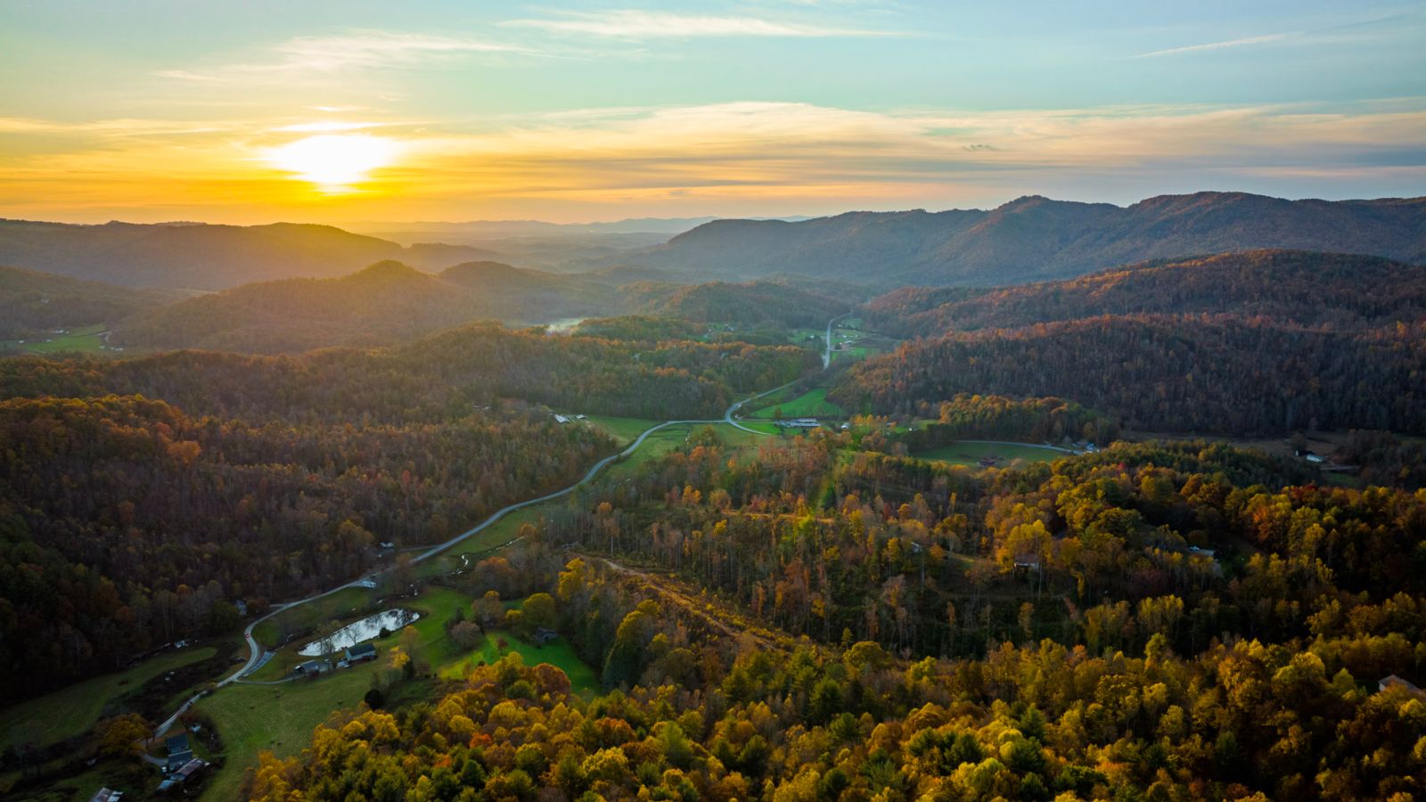
The Blue Ridge Parkway is America's most visited National Park unit and is known as "America's favorite drive." Its 469 miles offer stunning views of the Blue Ridge Mountains, spectacular mountain and valley vistas, quiet pastoral scenes, sparkling waterfalls, and colorful flower and foliage displays, with abundant hiking trails, picnic areas, campgrounds, and interpretive signage.
The lead designer of the famous roadway, Stanley Abbott, was a landscape architect, not an engineer. Influenced by Frederick Law Olmsted, designer of New York's Central Park and the grounds of Biltmore Estate, Abbott dreamed of creating a park-like environment as well as a road. Today, the completed Blue Ridge Parkway is a remarkable testament to his vision and is enjoyed by millions of visitors each year. It is certainly the most famous of all North Carolina's scenic drives.
Authorized as a public works project during Franklin D. Roosevelt's "New Deal," the Blue Ridge Parkway was built primarily by private contractors and the Works Progress Administration.
The Parkway is open year-round, but sections may be closed in winter due to ice and snow.
Access Points:
MP 229.7 - US Hwy 21 to Sparta & Elkin
US Hwy 21
Glade Valley, NC 28627
MP 248.1 - NC Route 18 to Laurel Springs & North Wilkesboro
Rt. 18
Laurel Springs, NC 28644
MP 261.2 - NC Route 16 to West Jefferson & North Wilkesboro
Rt. 16
Obids, NC 28694
MP 276.4 - US Hwy 421 to Boone & North Wilkesboro
US Hwy 421
Deep Gap, NC 28618
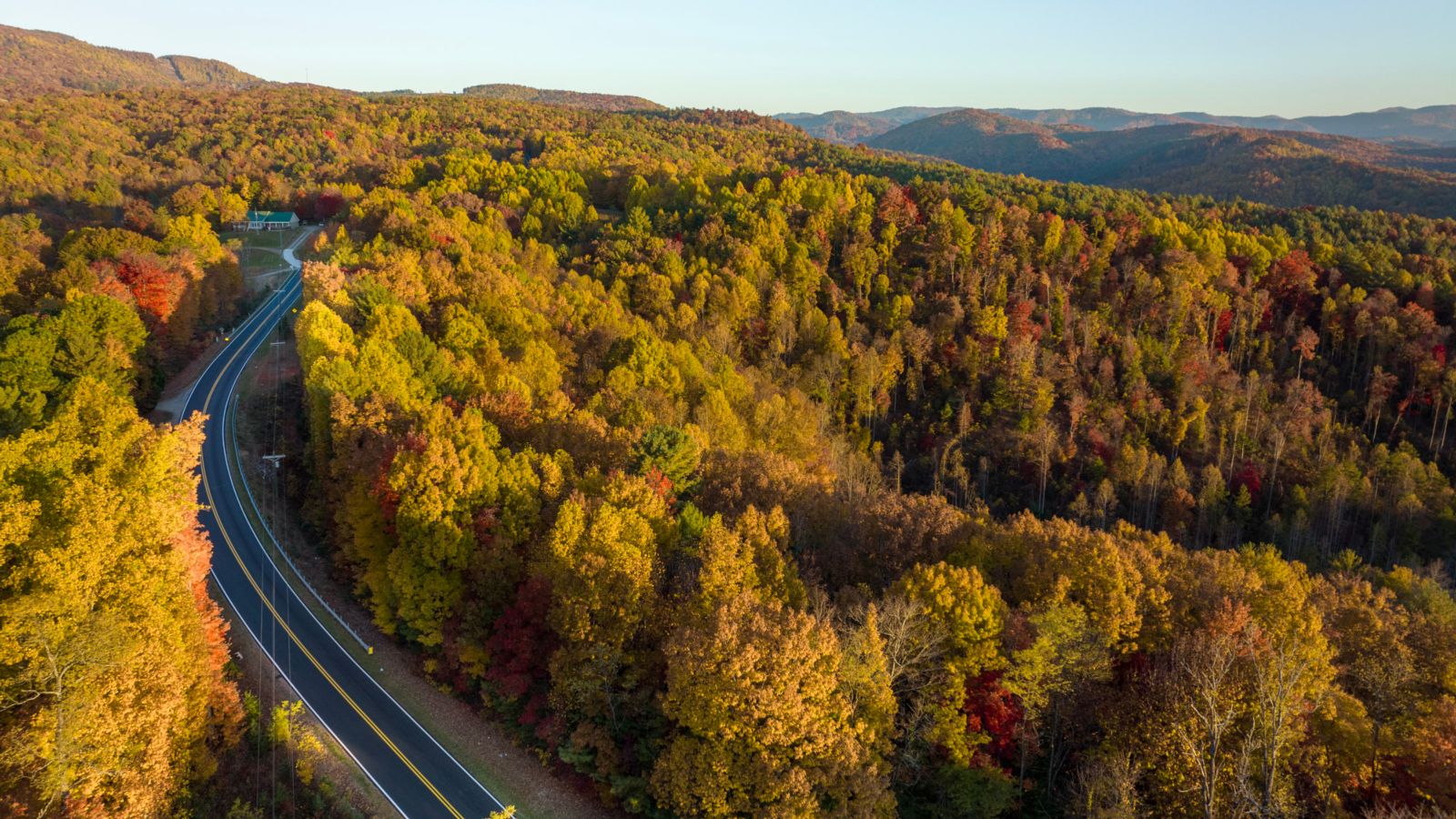
The U.S. 421 Scenic Byway travels through Watauga County’s portion of the Blue Ridge Mountains. The byway offers sweeping views of the valleys, woodlands and mountains between Deep Gap and Boone. It also runs near the home of multiple Grammy Award winner and cultural icon Doc Watson.
Begin following the byway along U.S. 421 North at the intersection with the Blue Ridge Parkway. The parkway crosses U.S. 421 on a bridge covered with native stones to reflect the beauty of the area. Often called “America’s Original Scenic Byway,” the National Park Service’s Blue Ridge Parkway travels 252 miles through North Carolina and provides exceptional views of the Appalachians.
Just after passing the Blue Ridge Parkway, the byway enters Watauga County near the town of Deep Gap, home of Doc and Merle Watson. Arthel L. “Doc” Watson, who was born blind, is a recording artist known for his unique music that blends traditional Appalachian styles with gospel, bluegrass and country. His son Merle joined him in his music career during the late 1960s and together they spread the Appalachian sound throughout the world until Merle’s untimely death in 1985.
Continuing north along U.S. 421, the byway passes the intersection with U.S. 221 and enters the New River Watershed. In 1999, President Bill Clinton named the watershed as one of the first American Heritage rivers. American Heritage rivers are designated by the U.S. Environmental Protection Agency to receive special attention for natural resource and environmental protection, economic revitalization, and historic and cultural preservation. The northward-flowing New River is believed to be one of the world’s first rivers. In fact, scientists believe that only the Nile River is older.
The byway then ascends a ridge, providing motorists with panoramic views of Snake Mountain and Elk Knob, which are a part of the Amphibolite Range. Along the way, motorists can take in views of the area’s hardwood and mixed forests, as well as horse and cattle farms. Also visible are a number of Fraser Fir Christmas Tree farms. Watauga County is a leading national producer of these firs.
After continuing through the communities of Brownwood and Laurel Springs, the byway ends at the South Fork of the New River and the Boone town limits. The New River provides recreational opportunities such as canoeing and fishing. Boone, the Watauga County seat, is the home of Appalachian State University. The Little Parkway (pg. 450), Mission Crossing (pg. 48) and New River Valley (pg. 52) scenic byways are located nearby.
The Upper Yadkin Way byway takes motorists on a scenic adventure through the state’s northern foothills. The route’s eastern terminus is near the W. Kerr Scott Reservoir in Goshen at the intersection of N.C. 268 and Reservoir Road (S.R. 1178). Follow N.C. 268 west toward Goshen. The reservoir was formed in 1962 for flood control and recreation and named for North Carolina Gov. W. Kerr Scott, who served from 1949 to 1952.
Pastures and farmland can be seen along this segment of N.C. 268 between Goshen and Ferguson, which follows the Yadkin River from the mountains through the foothills. The Yadkin River rises in Watauga County, near Blowing Rock, to the west. It eventually becomes a part of the Pee Dee River bordering Montgomery and Stanly counties.
Wilkesboro and Wilkes County were named for John Wilkes, an English political leader who supported American rights in the Revolutionary War era. The county was formed in 1778 and nearby Wilkesboro, the county seat, was laid out in 1801.
Not far from N.C. 268, in southwest Wilkes County near the town of Ferguson, is the grave of Thomas C. Dula. He is perhaps best remembered in the folk song “Tom Dooley,” and was hung in Statesville for the murder of Laura Foster in 1868.
Patterson, founded in 1851 with a textile-based economy, was named for Samuel F. Patterson, a prominent state official. The Morgan School at Patterson Reserve is named in honor of Samuel Legerwood Patterson and located on the plantation lands he gave to the school.
The upper Yadkin River in Caldwell County is known as “Happy Valley,” and was the site of prominent early settlers’ residences. South of Patterson is Fort Defiance, the restored 1790 house of Gen. William Lenoir, a Revolutionary leader and hero at the Battle of Kings Mountain. The house stands on the site of a frontier fort of the same name. It is open for tours the first and third Sundays of the month from April through November.
The byway’s western end is located at the intersection of N.C. 268 and U.S. 321 north of Lenoir, at the edge of the Pisgah National Forest. Now the Caldwell County seat, Lenoir was named for Gen. Lenoir. A few miles to the north is the resort community of Blowing Rock. (See the Little Parkway on pg. 50 for more information on Blowing Rock.)
Located in the western part of North Carolina, the Yadkin Valley Scenic Byway gives motorists the opportunity to see everything from gently rolling farmland to foothills and mountain terrain. The byway begins in downtown Elkin at the U.S. 21/Main Street/North Bridge Street intersection. Within walking distance of this point are the Foothills Art Council, Brushy Mountain Winery, Elkin Public Library and Crater Park.
Travel south on U.S. 21 to the Gwyn McNeil Bridge, which crosses over the Yadkin River. Follow this road for one mile until the Swan Creek bypass and take a right. Follow the bypass and turn left on Swan Creek Road.
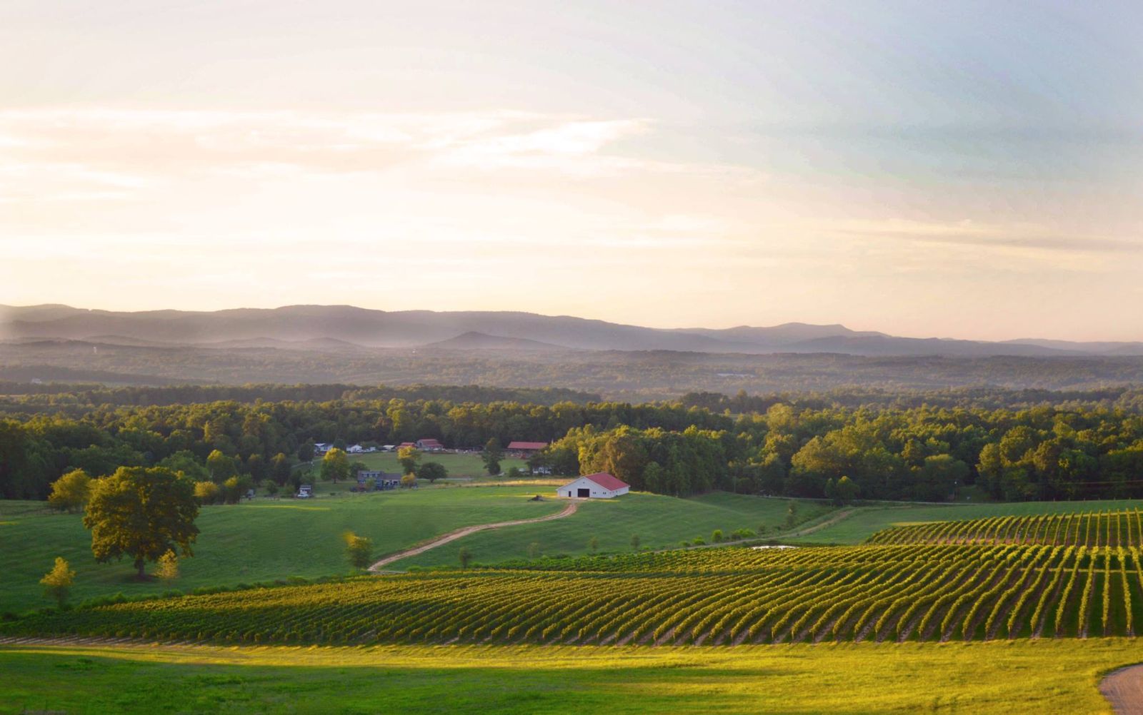
Until recently this area was known for its tobacco. Now the area is transitioning into the wine industry. Vineyards and wineries present along this route add a tremendous cultural asset to the driving experience. For those interested in sampling locally made wine, the Swan Creek Wine Trail gives motorists a great opportunity to tour several vineyards. Just make sure to have a designated driver.
Continue on Swan Creek Road until it ends at Old U.S. 421, reaching the southern end of the Western Appalachian Vine. Take a left onto Old U.S. 421, which is the beginning of the Central Appalachian Vine. Go one and a half miles and Laurel Gray Vineyards are on the left. Continue for another nine miles and the route will pass through Doweltown, just outside the Town of Yadkinville. Continue for half a mile and turn left onto North Lee Avenue. Cross over U.S. 601 onto Country Club Road and go for three miles until it intersects with Rockford Road and turn right.
After a little less than three miles, RagApple Lassie Vineyard and Winery will be on the right.
For a large portion of the route, motorists can see the unique knob of Pilot Mountain. The mountain, which rises 1,400 feet, was dedicated as a Natural National Landmark in 1976. The knob marks the center of the Pilot Mountain State Park.
Continue on Rockford Road for about one mile, passing through the Barney Hill Community. Richmond Hill Law School is located two and a half miles from Richmond Hill Church Road after the Rockford/Richmond Hill Church Road intersection.
Continue on Rockford Road for one mile, passing into Surry County over the Yadkin River. In southwestern Yadkin County, travelers can stop at one of two local general stores operated by the local Amish population. The stores are known for selling fresh produce and other various goods from the Amish. This region has a number of old-fashioned country stores which give motorists a taste of the local Yadkin Valley culture.
Continue on Rockford Road for another mile and pass through the Historic Village of Rockford. After four miles, the road intersects with Stony Knoll Road. Stony Knoll Vineyards is less than half a mile down the road on the left. William Cornelius Vineyard is located to the right one mile off the main route.
Continue following Rockford Road into the town of Dobson on U.S. 601 business. Travel about one and a half miles to the intersection with Kapp Street and turn left. The Historic Surry County Courthouse is located at this intersection. Fisher River Park is two and a half miles to the north on U.S. 601 Business.
Continue half a mile until Kapp Street becomes Zephyr Road and follow three miles to the intersection of Twin Oaks Road. The Salem Fork Community and Shelton Vineyards are located about two and a half miles down Twin Oaks Road.
Continue for two miles to where Zephyr Road intersects with Kapps Mill Road.
This point marks the end of the Central Appalachian Vine. From here, motorists can choose from two different routes. Follow the Western Appalachian Vine back to downtown Elkin or go on to the Northern Tendril, the mountainous route of the Yadkin Valley Scenic Byway.
To get back to downtown Elkin, turn left on Zephyr Road and go one and a half miles until Zephyr Road becomes Poplar Springs Road. Continue approximately eight miles until the intersection with U.S. 21. Grassy Creek Vineyard and Winery is located approximately one mile north of the U.S. 21 Bypass/Poplar Springs Road intersection.
To get to Klondike Road and Winery, turn right on the U.S. 21 Bypass and go a quarter mile before taking a left on Klondike Road. After three quarters of a mile, the winery will be on the left. Stay on U.S. 21 to get back to Elkin’s downtown area.
To access the Northern Tendril, travel down Kapps Mill Road for close to two miles until it ends at River Road. The Historic Kapps Mill and the Historic Kapp House, which was built in 1840, are located here.
Turn right on River Road and go three and a half miles until it ends at Haystack Road. Turning right on Haystack Road and continuing for four and a half miles until it intersects with Fisher Valley Road brings motorists by the Historic Edwards-Franklin House, built in 1799.
Continue on Haystack Road for another three and a half miles until it ends at Beulah Road. Turn right on Beulah Road and immediately turn onto I-77 northbound. Continue on I-77 for two miles and exit at N.C. 89.
Turn left onto N.C. 89. Go a half a mile on N.C. 89 and turn right on Round Peak Church Road. Go one and a half miles to Round Peak Vineyards. This is the end of the Northern Tendril and the Yadkin Valley Scenic Byway. Follow the signs to get back on I-77.
Click to download the complete State Scenic Byway's guide or contact us to receive your hard copy.